


024 la chapelle en faye Jas de Mas

MERMOZ33
User
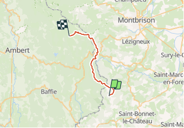

Length
24 km

Max alt
1272 m

Uphill gradient
535 m
Km-Effort
31 km

Min alt
1079 m

Downhill gradient
376 m
Boucle
No
Creation date :
2018-04-17 17:30:50.98
Updated on :
2018-04-17 17:30:50.98
--
Difficulty : Unknown

FREE GPS app for hiking
 SityTrail
IGN / Geographical institutes
SityTrail Plus
The world is yours!
About
Trail Walking of 24 km to be discovered at Auvergne-Rhône-Alpes, Loire, La Chapelle-en-Lafaye. This trail is proposed by MERMOZ33.
Positioning
Country:
France
Region :
Auvergne-Rhône-Alpes
Department/Province :
Loire
Municipality :
La Chapelle-en-Lafaye
Location:
Unknown
Start:(Dec)
Start:(UTM)
577389 ; 5034959 (31T) N.
Comments